World
Cork and Limerick to be linked by tolled motorway as further details of M20 project revealed

A motorway with barrier-free distance-based tolling has been recommended to link Cork and Limerick as part of the ambitious €1bn-plus N/M20 transport project.
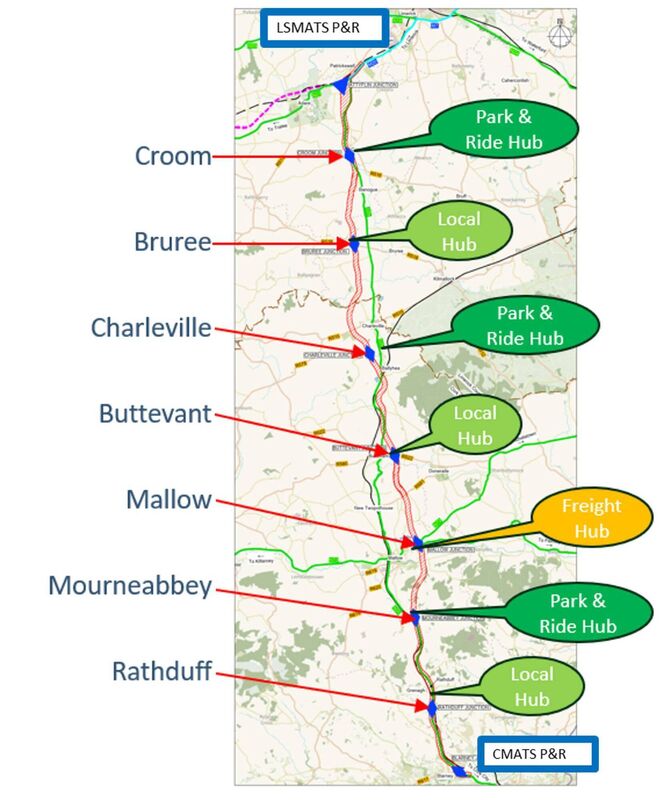
The locations of six transport hubs, each with EV chargers, park-and-ride connections to public transport, car-sharing options and connections to active travel links, as well as one freight hub with rest and welfare areas for truck drivers, have also been identified along the route.
The massive transport project, which includes some 100km of walking and cycling infrastructure, will be the largest single active travel project to be undertaken in Ireland, and the country’s first multi-modal transport scheme.
The details emerged on Monday during the latest briefing project by engineers for elected public representatives as design work on the scheme continues.
They said following a comparative analysis to investigate different forms of divided carriageways, motorway has now been chosen to link Ireland’s second and third cities.
It is five times safer than the N20 single carriageway, and once opened, will cut intercity travel times on average by 30 minutes, they said.
The toll on motorists will be collected using distance-based barrier-free tolling technology where motorists will pay based on the distance travelled on the new road, with pricing to be decided once the road is built.
“This multi-point system, rather than having one or two toll plazas, minimises the potential for toll avoidance activity,” engineers said.
Cork Chamber CEO Conor Healy — who has been advocating on behalf of the business group for several years for the scheme — welcomed the update but said its delivery must be accelerated.
He said: “While significant progress has been made and is recognised in getting to this announcement, the pace now needs to be accelerated with no further delays and full government approval forthcoming at the earliest opportunity to facilitate the project moving to the planning submission phase.”
The transport hubs will be built at key junctions on the route, including at:
- with parking for between 20 and 40 vehicles, with park-and-ride bus facilities, park-and-share facilities, and parking for onward travel on the active travel paths;
- with parking for between 40 to 100 vehicles, and the same facilities as the Rathduff site;
- with parking for between 20-40 vehicles, with park-and-share facilities and links to active travel pathways;
- with parking for between 40-100 vehicles, park-and-ride bus, and park-and-share facilities, and parking to connect to the active travel pathways;
- with parking for between 20-40 vehicles, with park-and-share and again, with links to the active travel network;
- with parking for between 40-100 vehicles, park-and-ride bus, and park-and-share facilities, and more parking to connect for onward active travel routes.

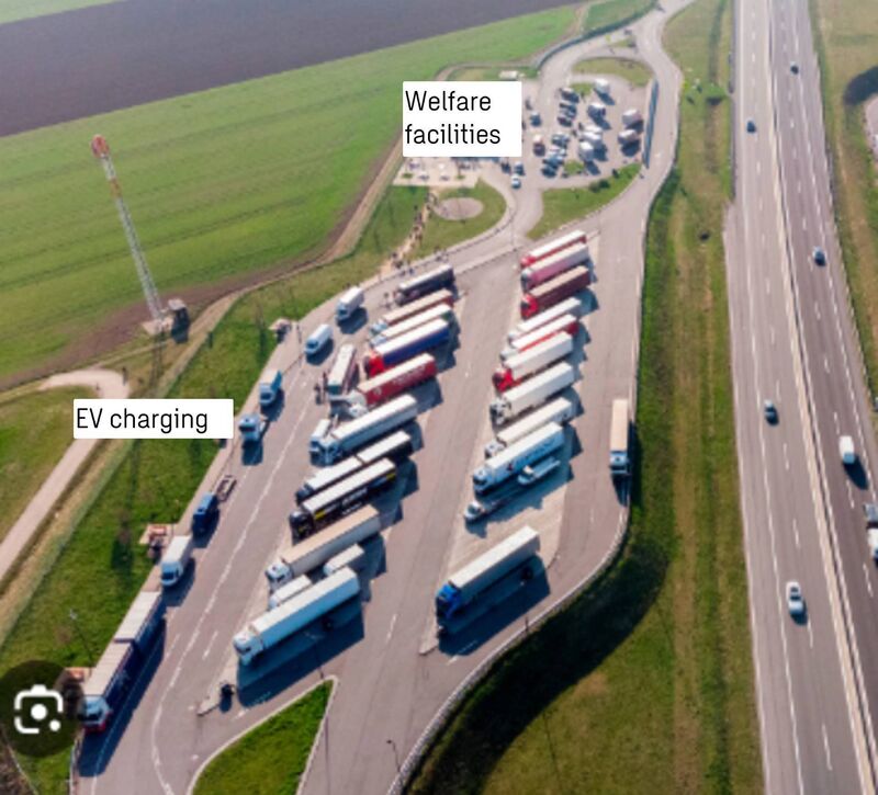
The freight hub for trucks will be built at Mallow, with secure parking for between 20 to 40 vehicles, a rest and welfare area for drivers, EV charging points for heavy goods vehicles, park-and-share facilities for onward transport to Cork City, if required, and again, parking and links to connect to the active travel network.
It is the latest project update since the preferred route corridor and overall transport solution was unveiled in March 2022.
Since then, the design team has been refining the overall design and mixed transport mode approach to re-use up to 40% of the existing N20 route, and build 80kms of high-quality dual carriageway.
At the last briefing in November, public representatives were told that the route corridor for the road had been narrowed to just 200m, the locations of most of the main junctions, of link roads, side roads and active travel corridors have been identified, but work is ongoing to further reduce the corridor to the road ‘fence-line’.
Of 100kms of walking and cycling infrastructure proposed, a shared bike and walkway will run along the motorway for some 62kms, with about 30kms of shared pathway being accommodated along sections of old N20, where road space will be reallocated to accommodate it.

The project also proposes upgrades to the rail link between the two cities with the development of an hourly, ‘no change’ train service, and improvements to the bus service between the two cities.
Public webinars outlining the latest updates for people affected along the route will take place on July 3 and 10, with more environmental surveys yet to take place.
Engineers expect to submit a business case to government by the end of this year in the hope of lodging a planning application to An Bórd Pleanála next year, which will hold an oral hearing.
It is only if planning is approved, and government funding is approved, that tenders can be published, which means construction is several years away yet.
The project is being overseen by Limerick City and County Council in partnership with Cork County Council, Cork City Council, Transport Infrastructure Ireland and the Department of Transport.


