
Travel
How a new app could show you green travel routes through Dublin

Analysis: using air quality data, the app would suggest routes through the city for pedestrians and cyclists avoiding the worst pollution
This article is now available above as a Brainstorm podcast. You can subscribe to the Brainstorm podcast through Apple Podcasts, Stitcher, Spotify or wherever you get your podcasts .
Urban areas are often packed with cars and trucks. While this makes transportation convenient, it also leads to pollution. The exhaust from these vehicles contains harmful substances that can hurt our health. For example, nitrogen oxides can irritate our lungs, carbon monoxide can reduce oxygen in our blood, and tiny particles can get deep into our lungs and even our bloodstream. This is especially concerning for pedestrians and cyclists who are closer to these pollutants. To make matters worse, living in areas with high pollution levels can have long-term effects on our health: It can lead to asthma, allergies, and even cancer. So, finding ways to reduce exposure to these pollutants is crucial.
Our team of researchers used data analysis to build a database and a prototype app that’s in development. Our starting point was to explore how real-world data can be applied to tackle the problem. Specifically, we explored the Google Air Quality dataset, which was recently made available to the public and contains rich information about air quality in various places and times in Dublin city.
This data can tell us which areas have cleaner air and which ones have more pollution. By using this data, we can suggest routes for walkers and bikers that avoid the worst pollution.
We need your consent to load this rte-player contentWe use rte-player to manage extra content that can set cookies on your device and collect data about your activity. Please review their details and accept them to load the content.Manage Preferences
From RTÉ Radio 1’s Drivetime, Dr Debbie Stanistreet, Associate Professor of Public Health in RCSI and member of Irish Doctors for the Environment, on Irish air quality
Here is how we do it
Data Collection: We obtain our data from Google’s dataset, which is collaboratively collected by Google and Dublin City Council in Dublin, Ireland. Google’s first electric Street View car (Figure 1), outfitted with Aclima’s mobile air sensing platform, traversed Dublin City’s streets, meticulously recording air quality on a street-by-street basis. The data collection primarily occurred on weekdays between 9:00 a.m. and 5:00 p.m. from May 2021 to August 2022.
Algorithm Creation & Route Optimisation: We develop a computer program that can take the air quality data and use it to find the healthiest routes for pedestrians and cyclists. The algorithm considers factors like the time of day and the distance of the route. Using the algorithm, they suggest alternative routes to users that have lower pollution levels. This way, people can choose to take paths that are healthier for them.
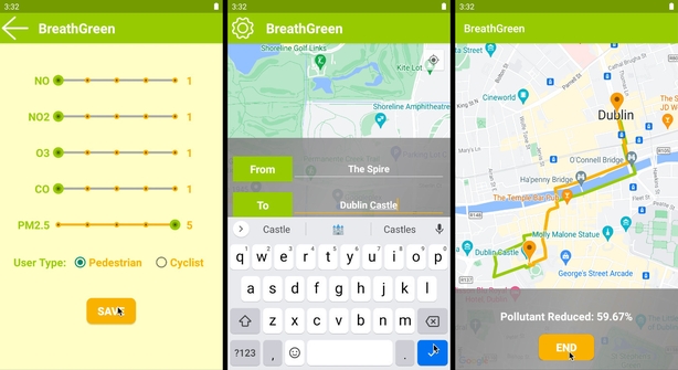
User-Friendly Interface: We make sure that the suggestions are easy for users to understand and follow, so a user-friendly smartphone app is developed, which is shown in Figure 2. Specifically, the Android app uses a map that users can input where they want to start and finish their trip. Then, it shows the routes with the shortest distance or the least pollution. Besides, users are enabled to customise the pollution index to match their preferences to specific types of pollutants, rather than relying on the default setting.
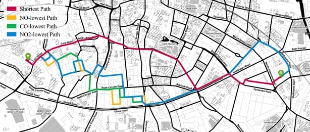
Performance Evaluation: Finally, we evaluate the efficacy of our developed algorithm by running statistical experiments. 1,000 trips with random origin-destination pairs were used to test our system. The results indicate that our system reduces the impact of air pollution by an average of approximately 18%, with a maximum reduction of up to 65%. Figure 3 shows various suggested routes for a journey starting near Coombe Hospital on Cork Street and ending near the National Print Museum on Lansdowne Road in Dublin. Notably, these routes start to differ noticeably around Donore Avenue.
Here’s how the app would change things
By using this approach, people walking or biking in the cities can enjoy multiple benefits:
Better Health: They can reduce their exposure to harmful pollutants, which can lead to improved respiratory and cardiovascular health.
Long-Term Wellness: Avoiding pollution can lower the risk of chronic illnesses like asthma and cancer.
Environmental Impact: Fewer people exposed to pollution means less pollution overall, which is good for the environment.
Convenience: Users can easily find routes that are both healthy and convenient for their daily commutes or exercise routines.
We need your consent to load this rte-player contentWe use rte-player to manage extra content that can set cookies on your device and collect data about your activity. Please review their details and accept them to load the content.Manage Preferences
From RTÉ News, air quality map for Dublin City released
Breathing clean air is essential for our health, especially for those who walk or bike in cities. Pollution from traffic can be harmful, but this project shows we can use data and smart strategies to make our urban environments healthier. By leveraging air quality data and suggesting cleaner routes, we can protect public health, reduce long-term health risks, and contribute to a cleaner environment. This research offers a promising solution to the challenge of balancing urban mobility and well-being.
The views expressed here are those of the author and do not represent or reflect the views of RTÉ

From Stadium to Screen: How Technology is Changing Sports Viewing

20/7/2024 Horse Racing Tips and Best Bets – Flemington, Flemington Cup day

Indian tech hub Karnataka state’s move to reserve jobs for locals not finalised, chief minister says

Financial picture dramatically improves for Shamrock Rovers in 48 hours with Sinclair Armstrong deal and European win

Our fashion editor’s favourite affordable bag is 20% off today

Jay Shah’s Big Decision Hovers Over Cricket’s Associate Member Directors Election

Budget shampoo that adds MAJOR volume boost is on sale for Amazon Prime Day: ‘Your hair feels fuller and thicker’

Being active on your commute lowers risk of disease and mental health

Tiger Woods cops brutal Open schedule as full Round 1 tee times revealed
